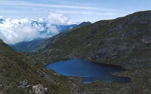
Rising into the clouds on the continental divide is the Talamanca mountain range, home to the montane rain forest, or cloud forest.
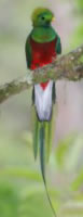
The region, which includes largely unexplored areas, is home to birds such as the Quetzal (pharomachrus mocinno) and several species of the Trogon family, and mammals such as the Jaguar and the Ocelot.
None of the mountains of the Talamanca range is considered volcanic. Its complete geological structure includes marine sediments, lava and igneous intrusions. Here we also find the Cerro Chirripo, highest peak in the country, which is host to the sub alpine and páramo ecosystems. Access to the peak in the Chirripó National Park is very difficult, but a good challenge for the serious hiker
The Talamanca range is accessible through he South Interamerican Highway, which makes it an ideal destination when in route to Corcovado and for bird watchers. |


