Atlantic
/ Caribbean Coast Travel Tips
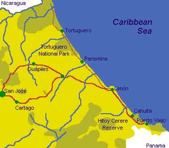
HOW TO GET THERE:
The drive to the the Caribbean Coast is a pleasant three hours over
the Central Mountain Range on the Guapiles Highway through the Zurqui
Tunnel (Costa Rica's only tunnel) and across the lowland plains. The
scenery changes dramatically from the dense tropical forests of Braulio
Carillo National Park through banana plantations and horticultural
farms to the coconut palm-lined roads along the coast. About 2 1/2 hours
driving time to Puerto Limon, 3 1/2 to Cahuita, 4 to Puerto Viejo, and
5 to Manzanillo.
CLIMATE:
This area is generally hot and experiences quite a bit of rain with
temperatures generally hovering between the mid to high 80's F. Since
the coast has the advantage of ocean breezes, the weather can be quite
bearable and pleasant.
- January & November are transitional periods with higher winds
and some rainy days
- February through May are generally sunny with a little rain
- July and December are the months of heaviest rainfall
- Mid-August through the first part of November is summer with the
least rain
WHAT TO WEAR:
Since the weather is extremely tropical on this coast, a hat and strong
sunblock are indispensable items. Clothing should be cotton and light
colored.
SIGHTS TO SEE:
At the Morpho Reserve just a few meters past the Corinto River, there
are trails and a beautiful variety of butterflies including the magnificent
Morpho butterfly. Vargas Park, an oasis of swaying palms, brightly colored
heliconias and winding paths is found in Puerto Limon. |